High Definition Mapping Services
Discover the next level of navigation and urban planning with Stesalit Inc.’s AI-enhanced High-Definition (HD) Mapping services. Our technology provides comprehensive, centimeter-level accuracy crucial for autonomous vehicles and smart city applications, ensuring safer and more efficient navigation.
Through innovative AI/ML based aerial digital data capturing solutions, Stesalit Inc. extracts accurate digital vector data from a host of sources, such as Aerial Photography, and Satellite Imagery. We offer a complete range of photogrammetric services for Topographic Mapping, Utilities Mapping, Road and Highway Planning, Cadastral Mapping, City Modeling, etc. Our services include consulting, project planning, software application development, image processing, data conversion and integration.
Stesalit Inc. has had extensive success in photogrammetric project planning and execution. We develop and use AI/ML based training models to extract data from the Satellite and Aerial Imagery. Our team is committed to develop and invest in emerging technologies, keeping up to date with advances in Mapping solutions and services at all times. Our services can be customized for project specific requirements, and we also execute large scale projects as contractors, from inception to completion.
Our HD Mapping Features:
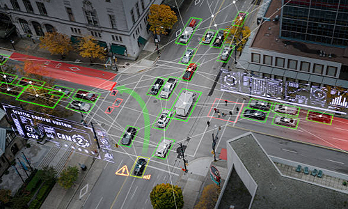
- AI-Powered Precision: Utilize AI algorithms for precise feature detection and road attribute classification.
- ML-Updated Maps: Machine Learning models dynamically update maps with real-time environmental changes.
- Seamless System Integration: Our HD maps integrate effortlessly with autonomous driving systems and urban infrastructure models.
Advanced Capabilities of Stesalit’s HD Mapping:
- State-of-the-Art Technologies: Employing the latest in LiDAR, GIS, photogrammetry, AI, and ML.
- Robust Data Processing: Our infrastructure supports large-scale data handling with high reliability and scalability.
- Expertise and Innovation: Our team specializes in geospatial technologies, ensuring cutting-edge solutions.
Transform Your Navigation Experience: Enhance your systems with Stesalit’s HD Mapping. Contact us to leverage our advanced mapping technologies and drive your projects towards unprecedented precision and safety.
HD Mapping Services