LiDAR Processing Services
At Stesalit Inc., we harness the power of Light Detection and Ranging (LiDAR) technology to provide you with detailed and accurate 3D representations of physical and geographical environments. Our advanced LiDAR processing services offer comprehensive solutions from data classification to feature extraction, tailored to meet the needs of various industries.
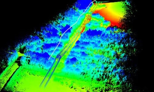
LiDAR (Terrestrial or Air Borne) data provides the point clouds that contain highest level of details of any object . LiDAR data contains highly accurate geo location and height above the ground—features such as Buildings, vegetation, power lines,poles, towers and roads are represented in 3D.
Stesalit Inc. offers LiDAR data classification, mapping and feature extraction services using AI/ML based training models. With proven methodologies and deep expertise in working with high-resolution imagery and LiDAR datasets, Stesalit Inc. enable customers to minimize the need for field visits.
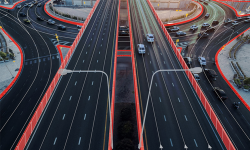
Stesalit Inc. LiDAR services to multiple industries such as transportation, utilities, telecommunications, mining, and engineering firms.
Explore Our Core Services:
- LiDAR Data Classification: Efficiently classify complex LiDAR datasets into meaningful categories.
- Detailed Mapping and Feature Extraction: Extract precise features like buildings, vegetation, and road infrastructures.
- 3D Modeling: Create detailed 3D models for urban planning, forestry, flood risk assessment, and more.
Industry Applications: Our services extend to transportation, utilities, telecommunications, mining, and more, reducing the need for extensive field surveys and accelerating decision-making processes.
Technology Driven by AI and ML: Utilize our AI/ML-enhanced methodologies to process high-resolution LiDAR data, ensuring accuracy and reducing turnaround times.
Why Choose Stesalit for LiDAR Processing?
- Expertise and Precision: Deep domain expertise ensures high-quality data processing.
- Customized Solutions: Tailored services to meet specific project requirements.
- Efficient and Cost-Effective: Minimize field visits and operational costs with our advanced remote sensing technology.
Get Started with Stesalit Inc.: Elevate your project’s precision with Stesalit’s LiDAR processing. Contact us today to learn how our LiDAR solutions can transform your data into actionable insights.
LiDAR Services